Monitoring deforestation in the Brazilian Amazon using Sentinel-2 imagery and Google Earth Engine
Time period: 2023 vs 2024
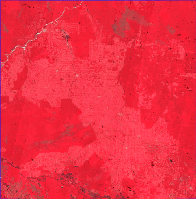
Focus area: Southern Rondônia / Northern Mato Grosso / Amazonas
Tech stack: Google Earth Engine, Sentinel-2 SR, Leaflet.js, GitHub Pages, Git LFS
🔗 Live map:
👉
Animated Change:
This project demonstrates a complete end-to-end remote sensing workflow for detecting and visualizing potential deforestation in the Brazilian Amazon.
It combines:
- Cloud-scale satellite processing in Google Earth Engine
- NDVI-based change detection**
- Vectorization of forest-loss hotspots
- An interactive Leaflet web map for public dissemination
Due to computational and export constraints of the full Amazon basin, the analysis focuses on a high-deforestation sub-region (~300,000 km²) within the Arc of Deforestation.
- Detect potential forest loss between 2023 and 2024
- Quantify the approximate forest loss area
- Visualize results in an interactive web map
Deliverables
-
Public Google Earth Engine script
-
Forest loss summary statistics
-
Animated year-to-year visualization
-
Interactive Leaflet map with:
- Year toggle (2023 / 2024)
- Independent deforestation hotspots layer
- Clickable polygons with area estimates
AOI: Southern Rondônia, northern Mato Grosso, and Amazonas
- Bounding box: [-65°, -13°] to [-60°, -8°]
- Approximate area: ~300,000 km²
- Known region of accelerated deforestation
Defined in GEE as:
var testAOI = ee.Geometry.Rectangle([-65, -13, -60, -8]);Amazon Basin

Area of Interest:

Dataset
- Sentinel-2 Surface Reflectance
(
COPERNICUS/S2_SR_HARMONIZED)
Key parameters
- Cloud cover < 50%
- QA60 cloud & cirrus masking
- NDVI = (B8 − B4) / (B8 + B4)
Annual composite
- Per-pixel maximum NDVI quality mosaic
- Prioritizes cloud-free, healthy vegetation observations
-
Generate max-NDVI mosaics for 2023 and 2024
-
Compute NDVI difference:
NDVI_2024 − NDVI_2023 -
Flag potential deforestation where:
- NDVI drop ≥ 0.20
- 2024 NDVI < 0.55
Estimated potential forest loss -> ~579 km² (coarse 100 m estimate)
| Metric | Value |
|---|---|
| Sentinel-2 images processed (2023) | 2,684 |
| Sentinel-2 images processed (2024) | 2,518 |
| Mean NDVI (2023) | 0.832 |
| Mean NDVI (2024) | 0.835 |
| Estimated potential forest loss | ~579 km² |
- False-color composites (NIR–Red–Green)
- NDVI layers
- NDVI change map
- Binary forest-loss mask
- Extracted using
reduceToVectors - 60 m scale, simplified geometries
- Exported as GeoJSON (Git LFS)
🔗 Click Here
Features
- Toggle between 2023 & 2024 imagery
- Independent deforestation hotspots checkbox
- Clickable polygons with area (ha)
- Legend and contextual info panel
| Challenge | Solution |
|---|---|
| Full Amazon too large | Scoped to high-priority sub-region |
| Export limits | Raster exports at 30 m, vectors at 60 m |
| GeoJSON >25 MB | Git LFS + media.githubusercontent.com fetch |
| Local CORS issues | Local HTTP server for development |
| Web performance | Geometry simplification + lazy loading |
- Annual comparison only (no seasonal dynamics)
- Conservative NDVI thresholds
- Coarse area estimates
- Sub-region not representative of the entire Amazon
- Small patches may be merged or lost during simplification
- Monthly or seasonal NDVI time series
- Expanded coverage (Arc of Deforestation)
- Validation with MapBiomas / Hansen GFC
- Time slider animation in Leaflet
- Area-weighted statistics and dashboards
- Vector tiles (PMTiles) for large-scale performance
This project showcases a scalable, reproducible, and visually intuitive workflow for monitoring deforestation using open satellite data and modern web mapping tools.